Thursday, June 21, 2007

Spring paddling


Here are a few pictures from some kayaking trips this spring. It has been a busy one. I'd say more, but the images say plenty.


Loose Ends

It has been a long time since my last post, and a great deal has happened in the time that has passed. The following are a few images from the last 6 months or so.


Nothing like winter in the Cascades! The highest annual snowfall in the country.

My winter playground-Cowboy Ridge, Stevens Pass Backcountry


The 21st Annual Mt Baker Banked Slalom with Mt Shuksan in the background. It was a great weekend. Laura got in the race this year and ran the same course as 4 Olympians.


A snowboarders Mecca-The Hemispheres, Mt. Baker Backcountry

Sunday, March 18, 2007

Wenatchee Kayaking @ 5500cks

Wenatchee Kayaking @ 5500cfs -March 07

Wednesday, February 07, 2007

Ice climbing in Leavenworth-Feb 2007

After a prolonged period of cold weather there was more ice in the Leavenworth area, and Washington is general for that matter, than there had been in several years. This combined with the lack of fresh snow resulted in our snowboards being sitting idle while the ice tools came out hibernation.

Early Saturday morning Gloria and I woke up early and drove to original destination near Mountaineers Creek, a tributary of the appropriately named Icicle Creek and met our friends Jason, Dave, Brad and Reuben. Unfortunately a series of comedic errors prevented us from doing the routes near Mountaineer Creek so and we ended up climbing at an area known as Rainbow Falls which required a much shorter.


My friend Dave Moroles leading the pitch rated at WI4+. (left)


Me toproping the pitch thanks to Dave. (above and left)

Friday, October 27, 2006

Professor Paddle Crew 2006 paddling

clips from the 2006 Washington State whitewater season

Tuesday, October 24, 2006

The Enchantments

The Enchantments are a spectacular collection of lakes and pearly white granite peaks located high above the town of Leavenworth Washington. The area is incredibly beautiful and so popular that a strict permit system limits the number of visiters from June 15th to Oct 15th. While you can visit in the off season, the high elevation means that it is often snow covered during that time. This year however, the usual mid October storms had not yet arrived so my friend Reese and I decided to make the long hike in and do some climbing.

While the Enchanments are beautiful, the price of entry into this alpine wonderland is sweat and sore quadreceps. To reach the our campsite, Reese and I hiked in 9 miles, a relatively short distance if not for the 5000ft+ elevation gain. The last 2500ft are gained in the 1.5 miles between Colchuck Lake and Aasgard Pass.

Alpine meadows


Pearly white granite and golden larches


Prusik peak and alpine lakelets


Witches Tower (left) and the backside of Dragontail Peak (right)


On a previous trip to the area I climbed Prusik Peak (shown above) and Enchantment Peak. During our trip however the cold temperatures (ranging from 20F at night to around 35F during the day) prevented us from doing any technical climbing. We did however take the time to scope out some possible routes on Witches Tower and a few other peaks in the area. It was a bit frustrating to leave the area without climbing something technical, but there will be other trips.

Monday, September 11, 2006

Ashlu Whitewater Festival

As the water levels in Washington's rivers drop below runnable levels the rivers in western British Columbia are just dropping to reasonable levels. With the water in Washington all but gone, the Ashlu River Festival provided me with the excuse I needed to make the drive north and check out the Canadian whitewater scene. Unfortunately, none of the photos I took on the trip came out but I was able to take a few on a recent climbing trip in BC.

The canyon below the Calheak run

The Whistler bungee bridge over the Cheakamus Canyon
The Cheakamus Canyon
The glacial waters of the Cheakamus
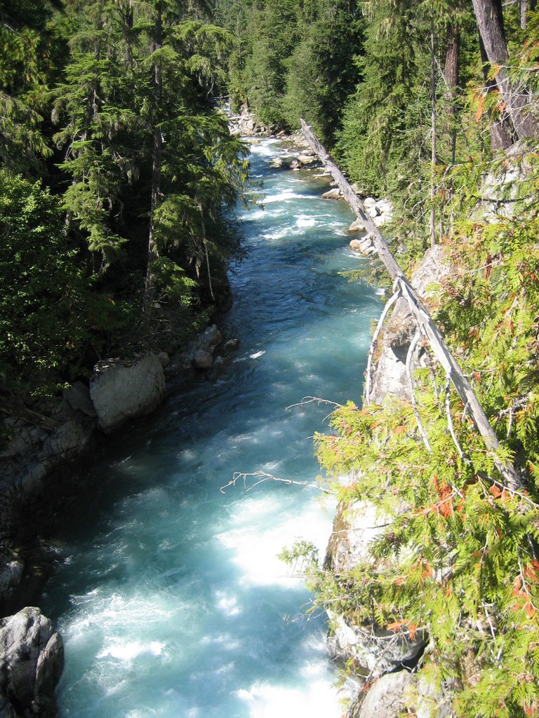
While at the Ashlu Festival I had a chance to paddle runs on the Ashlu, Calcheack, Elaho and Squamish Rivers. The number of quality runs in this area is incredible and the views as you paddle beneath the heavily glaciated peaks are awe inspiring.

The link below has some great pictures and descriptions of the various runs on the Ashlu as well as other rivers in the area.
http://www.paddleguides.com/rivers/bc/ashlu/ashlu.html

Lake Josephine

A few weekends ago Gloria and I went on a short backpacking trip to Lake Josephine, a small lake just off the Pacific Crest Trail a few mile south of Steven's Pass. Getting to the lake involved an enjoyable hike to up and over the ski area, then over one mare small ridge before arriving at the lake.

Lake Joesephine

Lush vegetation


Emerald green watersOn the hike out we took our time, enjoyed the sunshine, and feasted on the ripe blueberries growing in heather meadows lining the trail.

Monday, August 07, 2006

Tumwater Canyon, 6-3-06

Tumwater. For most paddlers in the Pacific Northwest, this name evokes fear. The name is derived from a Chinook word meaning violent water, a good indication of the character of the Wenatchee River just upstream of Leavenworth Washington.
For me, this stretch of river symbolizes a stepping stone to the next level in kayaking. While it is a far cry from the hardest stretch of whitewater in the state, running it successfully signifies ones passage into the realm of class V boating. I felt I was up to the challenge, but I was still terrified.
At 11am on Sunday morning I met Dan Ruiz, who was also running Tumwater for the first time, along with the rest of crew. In all we had 15 paddlers so we broke up into two groups, loaded up the cars, and drove to the Swiftwater picnic area to put in.
Below the picnic area class II and III rapids dot the river providing us with an opportunity to get comfortable in our boats and prepare for the real fun which awaited us downstream.

Dan in: The Wall

The first significant rapid is a quarter mile long series of class IV ledges, chutes and holes known as The Wall. The rapid is so long we scouted it three times, once at the entrance, and twice more before the end of the difficulties. I was very nervous as I paddled into the Wall and, as a result, I failed to stay loose and flipped a short distance into the rapid. Luckily, I was able to maintain my composure, roll up quickly, and get back on line. After that I settled into a groove and started to paddle better.
At the base of The Wall, easy class III and III+ rapids continue for a short distance before the river enters Lake Jolanda. This small lake is formed by a dam a couple hundred yards downstream. I portaged the dam, but a few people ran it. After seeing someone run the dam I realize that it is intimidating but not very difficult and I'll probably give it a try next time.


A mile or so of class III and III+ paddling continues below the dam before the next major rapid appears. Chaos Cascade is class IV, and similar in character to the Wall, but much shorter. The crux of the rapid consists of a river wide ledge with several slots to choose from. I chose to run the middle slot and hit it, as well as the rest of the rapid, cleanly.


The last rapid is POW, short for Perfection of Whitewater. This rapid was the hardest of my run and is rated class V. I spent a long time looking at this rapid before deciding to run it. It was by far the most intimidating rapid of the run. The lead in involved running a couple of 2-3 ft ledges on river left before moving to the right side of the river to punch two BIG holes.

James punching the big hole in POW. (photo by Dave D1 Morrison)

After POW, there is one more significant rapid. Exit is a class V+ series of huge holes and ledges that must be run down the center to avoid potentially dangerous undercut rocks on both sides of the river. If you get pushed too far left or right, you risk getting stuffed under the rocks and not coming back out. Even though I'm pretty sure I could have made the moves, I portaged the rapid. Running something with that much danger was simply too risky for me. Three members of my group did run Exit, and thankfully, they made it look easy.

All in all, it was a great trip that boosted my confidence on the river. I'm already looking forward to running it again. Hopefully, I'll be a little less nervous next time.

Here is a link to another Tumwater trip report at the same level with some great pictures and video. http://riverlog.blogspot.com/2005/02/tumwater-canyon.html